Prasenjit Singh
Commissioner of Income Tax, (TDS), Vadodra
prasenjit.singh@incometax.gov.in
 Sh. Prasenjit Singh is an IRS officer of 1990 batch and is currently posted as Commissioner of Income Tax, TDS, Vadodara. The present article is based on the appellate order passed by him as Commissioner (Appeals). Relevant extracts from this order has been reproduced. However, the name of the assessee has been muted. This order was widely appreciated and the author was awarded the title of ‘BEST INNOVATOR’ in the charge of Pr. CCIT, Gujarat for the exceptional ideas utilized in the appellate proceedings.
| Executive Summary
The present article is based on the appellate order passed by me as Commissioner (Appeals). Relevant extracts from my order have been reproduced. However, the name of the assessee has been muted. This order was widely appreciated and the author was awarded the title of ‘BEST INNOVATOR’ in the charge of Pr. CCIT, Gujarat for the exceptional ideas utilized in the appellate proceedings. |
The above popular number by Bob Dylan has a strong message, not restricted to the music or literature but applicable to the taxation as well. Let us see how.
1. In large number of cases in a South Gujarat district, on behalf of a big group planning a factory, huge parcels of land were acquired and compensation was paid towards land acquisition which included compensation for land and non land component such as structures, wells, farm house, trees, crops etc. The total payment of Rs. 245 crores was made to 529 persons. This payment was made towards land cost but also included the payment of Rs. 90 crores made for non-land component (Construction/ Structures/Well, agriculture crops, trees, etc.) The land acquisition was carried out from 2001 onwards to 2006 and compensation payments were made from F.Y. 2007-09 to 2011-12. In all the cases of compensation payments, reassessment proceedings were initiated. The assessment was completed in more than 250 cases and appeals were filed against the reassessment proceedings. The CIT(A) while dealing with few of these appeals noticed that in some cases the payment for the ‘non land component’ which included construction/structures/Kaccha Huts/WC/Well, etc., trees, agriculture crops was unusually high vis-à-vis the compensation received for the land. The main challenge was that the cases were being decided in FY 2015-16 while the events of acquisition and financial transactions had taken place several years ago. Whether there existed any structures, trees, crops etc. were not ascertainable. In order to verify the basis and authenticity of these payments made for the ‘non land component, a reference was made to National Remote Sensing Centre (NRSC) Hyderabad under ISRO to determine from the analysis of the Satellite Images since 1999 upto 2012 regarding the nature of the crops produced, number of trees existing, and whether any construction/structure existed or not.
2. In one of such cases of land acquisition and receipt of large compensation, the reassessment proceedings were initiated by the AO in an individual case named MSP for AY 2008-09. The assessee had received a large compensation from Land Acquisition Officer. The compensation consisted of price of land (Rs. 30L) and also towards structures on the land (Rs. 170 L). These were not disclosed in return for the said year.
3. The Issue and Challenges:
The payment of compensation by E. Steel Ltd was made under two broad categories:
a. The payment made towards acquisition of land.
b. The payment towards non land component which included payments made under the following heads:
- Construction/structures/Kaccha Huts/WC/Well, etc.
- Trees
- Agriculture Crops
- The majority of the land acquisition was completed by 2004 and the payment for the land acquisition was started from F.Y. 2006-07 on wards. The issue which required investigations was that in some cases the compensation payment for the ‘non land component’ which included construction/structures/Kaccha Huts/ WC/ Well, etc., Trees and agriculture crops, was unusually high vis-à-vis the compensation received for the land.
- 570 such cases were reopened in u/s 147 of the IT Act in AY 2012-13 i.e. after more than 3 – 6 years of actual transactions had actually taken place. The challenge was how to ascertain the facts of existence of agriculture crops, trees and structures for which huge payments had been made after so many years. The availability of the historical data is always a challenge.
c. Before the AO, the assessee objected to the reopening of case and pleaded that the land in question was agricultural land, not liable to capital gains. The AO after allowing sufficient opportunity and after going through the details in respect of agricultural operations done on said land, rejected the claim of assessee and passed an order by determining the income at Rs. 2,20,83,800/-, a week before the closing of financial year 2012-13 and raising demand of Rs. 1.10 Crore. The AO also rejected the claim of section 54B and initiated penalty u/s 271(1)(c).
d. Similar exercise was undertaken for two more individual cases which are all related to each other. Dissatisfied with the assessment order, an appeal before the Commissioner (Appeals) was preferred challenging the reopening, LTCG not treated exempt, charging interest and initiating penalty for concealment.
e. The appellant was provided with 12 opportunities to defend his case by Commissioner (Appeals), but no compliance was made. The Appellate authority had to explore other options to obtain sufficient information on the case. Some similar cases were already disposed off in the same Appellate office and observations/documents/ decisions in such cases were found relevant for the present appeal also.
f. The acquired land was situated in a Notified Area. The Notification of Industries and Mines Department, Government of Gujarat and Gujarat Municipalities Act, 1963 (GUJ 34 of 1964). This Act, dealing with the Notified Area defines the notified areas as urban area or part thereof specified as notified area to be an Industrial Township Area under the provisions of Clause – I of article 243 Q of the Constitution of India. It has been expressly clarified that the provisions of Gujarat Panchayats Act ceased to apply in respect of notified areas from the date of notification.
g. The assessing officer had formed his `reason to believe` perceiving the corresponding Capital Gains had escaped assessment as the lands acquired was capital assets u/s 2(14) of the Act and corresponding Capital Gains was not offered for tax by the appellant. The AO also referred to the Census register of the area and on the basis of above information, the assessing officers held that total of population of all the villages taken together exceeds 10000 and such total population should be considered for the purpose of section 2 (14)(iii)(a) .
h. MY OBSERVATIONS AS COMMISSIONER (APPEALS)
(a) The land acquired/sold/transferred was not an agricultural and therefore, it was a Capital Asset in view of section 2(14) of the IT Act.
(b) Without prejudice to the above finding that the land sold/transferred/acquired was not an Agricultural Land, the issue of applicability of section 2(14)(iii)(a) and (b) is only of academic interest as it has been held that the land sold/transferred/ acquired was not an agricultural land and therefore, it was a Capital Asset u/s 2(14) of the IT Act.
© As regards the indexed ‘cost of acquisition’, it has been held that the fair market value of the land would be taken @ 2.05 per sq mtr. as on 01.04.1981 and the indexed ‘cost of acquisition’ for the purpose of Long Term Capital Gain would be worked out accordingly.
(d) As regards deductions u/s 10(37) of the Income Tax Act and 54B, the issues have been decided against the appellants for the reason that the land itself has not been held to be an ‘agricultural land’. Moreover, there has been no evidence of any agricultural activity in the immediate past, in respect of the said land.
(e) As regards compensation/sale consideration for other immovable assets on the land like pakka house, pakka huts, trees, water tank, etc, the said assets are treated as distinct and separate capital assets and he corresponding compensation/consideration has not been treated as compensation/ consideration for the land.
(f) The said compensation/consideration for other immovable assets has been assessed under the head STCG and not under the head ‘income from other source’ as done by the AO.
(g) On estimate basis, deduction for indexed cost of acquisition has been given @ 5 0 % o f the consideration / compensation received, in respect of such other immovable assets
(h) Investment in the immovable assets is to be taxed u/s 69 of the I T Act and the investment value is to be taken as deemed income under the head `Other Sources` . The year of taxability of deemed income will be the year, in which, the investment is detected i.e. the year to which, the appeal pertains to. This means 50% of the compensation received for other assets is assessable under the head ` Other Sources`,
(I) As regards issue of notice u/s 148 of the Act, the validity of notice u/s 148 has been upheld as there has been no scrutiny assessment earlier and the notice u/s 148 was issued within 4 years from the end of relevant to assessment year. Moreover, the assessing officer had duly recorded his/her reasons to believe regarding escapement of income from tax alter considering the material received from the concerned authorities of the State Government regarding consideration paid for acquisition/sale of land/ other properties.
i. During the course of the appellate proceedings, it was noticed that the appellant had received payment for his land survey no. Xxx-Yyy of Rs. 30,00,000/- as compensation for land and R s . 1 , 7 0 , 0 0 , 0 0 0 / – towards construction/structure s/Kaccha Huts/WC/well, etc. In instant case, the payments made by Xxxx Yyyyy Ltd. towards non land component was found to be unusually high vis-à-vis the compensation received for the land. The non land component included payments made towards the:
- Construction/structures/Kaccha Huts/WC/Well, etc.
- Trees
- Agriculture Crops
j. SATELLITE- A TAX GUY IN THE SKY ENTERS THE SCENE
The follow up, so far chained to the earth, rose to ‘Stratosphere’ in appellate proceedings. Historic satellite data is the only means to get the past information of different features.
k. Taking into consideration the fact, that payments had been made of large amounts on account of construction, trees, crops, etc., which was unusual, abnormal and uncommon as normally the quality of construction, etc. in rural areas is of inferior quality, it was decided that further enquiries need to be done in these cases. In order to verify the basis and authenticity of these payments made for the ‘non land component, a reference was made u/s 250(4) of the I T Act, 1961 to National Remote Sensing Centre (NRSC) Hyderabad under ISRO to determine from the analysis of the Satellite Images since 1999 upto 2012 regarding the nature of the crops produced, number of trees existing, whether any construction/structure existing on the 61 parcel of land for which the compensation had been paid.
l. This reference made to NRSC, Hyderabad included as the initial measure, an exercise for the collection of basic data before making a request to NRSC, Hyderabad. As a first step, a reference was made to Bhaskaracharya Institute for Space Applications and Geo-Informatics, Gandhinagar, Gujarat, also known as ‘BISAG’. This institute is a State Level Nodal Agency established by Government of Gujarat, to facilitate the use of spatial and geo-spatial technologies for the planning and developmental activities pertaining to Agriculture, Land and Water Resource Management, Wasteland/Watershed Development, Forestry, Disaster Management, Infrastructure and Education. The list of 61 Survey Numbers of the land acquired by E. Steel Ltd in the H. Notified Area was provided to ‘BISAG’ in June 2015 to locate these 61 survey numbers and get it marked it on the maps of Gujarat with the size and shape of the land as per the survey number. The required data was provided by BISAG. This data provided by BISAG was having background satellite data with shape file and scanned cadastral map for the useful interpretation by National Remote Sensing Centre(NRSC), Hyderabad under ISRO.
m. This mapped survey numbers with size and shape was sent to NRSC, Hyderabad, for obtaining the images of land as per the survey numbers alongwith the crops, trees, constructed structures (tube well, house, shades, etc.) to determine whether the kharif, rabi or summer crop was produced on these lands or not; whether any construction/ structure was existing on these land during the period 1999 to 2006.
n. The mapped survey numbers with size and shape was used by NRSC vis-à-vis the remote sensing technology which has historic data base on the study area, to derive information on land use features like the crops, trees, water bodies, settlements and structures and the changes in the land parcel that has taken place over the years. The remote sensing technology advantage is that each feature on earth has different pattern, shape, texture, tone, etc. These different land covers are distinctly manifested in the satellite data in the form of different image elements viz., the tone, the texture, the pattern, the shape and the association, etc. The analysis of these elements provided information with respect to the identification of these land cover features. Satellite data is amenable to geo-referencing, by which the coordinates of the image could be matched to that of the real world. This enabled NRSC to map different features on the Earth’s surface. Further, analysis of the multi-temporal data enabled NRSC to detect the changes the different features are undergoing, either naturally or through man-made activities. In addition, historic satellite data is the only means to get the past information of different features. In light of these advantages, NRSC used the remote sensing satellite data by employing appropriate geospatial analytical techniques.
o. The NRSC for the analysis of period from 1999 to 2012, the corresponding cloud-free high resolution imagery of Indian Remote Sensing Satellites were selected. For the years 1999 to 2003 the analysis was carried out using the then available panchromatic data of IRS-1C / ID with 5.8 m resolution and subsequently multi-spectral LISS-IV data of Resourcesat-1/2 with 5.8 m resolution were used. Since 2006 the Cartosat-1 Panchromatic data with a spatial resolution of 2.5m was used in the analysis. Seven imageries of and IRS-1C/D PAN, six imageries of Cartosat-land 15 multi-spectral LISS-IV of Resourcesat-1/2 images were used in the analysis.
p. An amount of Rs.2,50,000/- was paid to NRSC, Hyderabad for obtaining the Satellite Data from the various satellites. In some cases, where the data was not available with the Indian Satellites due to clouds, etc., the data was obtained from the International Satellites by NRSC, Hyderabad for the same.
q. The study used (i) master reference satellite data, (ii) satellite data for the reference period, (iii) cadastral map of the H. village along with shape file. Soft copy of the cadastral map in JPEG format, shape file of the selected parcels with revenue/survey number as well as the paper-print hard copy were provided by this office. The methodology employed essentially comprised of two broad steps viz., (1) geo-referencing the satellite data and the shape file and (2) interpretation of the images. The methodology followed in this study is presented in Fig. v

r. In the report of the NRSC, Hyderabad which was received in September 2016, it was found that no agriculture activity or evidence of any crops have been found on the various parcels of land including the appellant’s land (Survey No. Xxx-Yyy from the period 1999 to 2012. Only scrubs were found with no signs of any crops or vegetables on the said parcel of lands. It was also pointed out that no construction/structure was found on the said land till 2006. Subsequently a show cause notice was issued to the assessee on 08.02.2017 which is as following :-
“During the course of appellate proceedings, it was noticed that you had received compensation from M/s Xxxx Yyyy Limited during the A.Y. 2008-09 for ‘acquisition of land’ for Survey No. Abc-xyz. The records show that you had received the following amount of compensation for acquisition of land.
In order to verify the genuineness of the above payments received by you on account of crops, trees and construction, an inquiry was conducted by this office u/s 250(4) of the Income Tax Act, 1961. The details of your land alongwith survey number was communicated to the National Remote Sensing Centre,(NRSC) Hyderabad, so as to determine after analyzing the satellite images the following issues:
a) Whether kharif, rabi or any other summer crops were/ was produced on this piece of land or not or any agriculture produce had been produced since year 1999?
b) The number of trees existing on this piece of land since year 1999?
c) Whether any construction/structure was existing on this land, since year 1999?
The NRSC, Hyderabad in its report has informed the following facts in regards to your land:
i) No agricultural activity or evidence of any crops have been found on this piece of land at Survey No. abc from the period 1999 to 2012.
ii) The number of trees on your land have been estimated at ______, to be existing on this survey number. While as per the report of the Forest Department who had conducted the survey for determination of the types of trees, during the pre- acquisition period had reported that only 2 types of trees were found therein, which are namely
(i) _____________ ( ii) _____________. The report dated of Forest Department
iii) The reports of the NRSC, Hyderabad points out that very small area of construction (less than 5% construction was found) on the land bearing Survey Number abc for which payment to the extent of Rs. 1,70,00,000/- has been made to you .
The relevant portion of the report (Satellite Images) of the NRSC, Hyderabad pertaining to your land is enclosed with this show cause letter. In view of the findings of the NRSC, Hyderabad, you are hereby directed to furnish your reply / clarification on this issue, with documentary evidence, by 27/02/2017 to this office, failing which, it will be assumed that you had nothing to submit on this aspect and the appeal will be decided on the details available on record.”
s. This show cause notice was issued on the address given by the appellant in Appeal Memo (Form No.35) and was duly served on the appellant on 10.02.2017 as per the Speed Post on line tracking. In response to the show cause notice, no compliance was made by the appellant and no clarification was submitted. The appellant sought adjournments only and no reply was filed. The finding by the NRSC, Hyderabad which was confronted to the appellant proves that there existed no construction/ structure, etc of any kind on the said land. It was also pointed out that no construction was found on Survey No. Xyz-abc. By no stretch of imagination the payment for this no construction can be made of Rs.1,70,00,000/-while the total payment for the land is only Rs. 30,00,000/- which itself proves that the payment made for the no construction can be thousand times more than the land cost. The compensation received by the appellant cannot be considered to have been paid towards construction/ structure, etc. and therefore the amount of compensation of Rs. 1,70,00,000/- received will be treated as income from other sources as held by the AO in the assessment order.
The copy of the Satellite Imaging Report by NRSC, Hyderabad is enclosed as Annexure A of this appellate order.
t. Keeping in view, the above findings of the CIT(A) while adjudicating the various appeals on the various similar issues raised in the grounds of appeal in this appeal, the various grounds of appeals are being decided accordingly as following:
| Ground No. 1 | Dismissed– The reassessment proceedings are valid |
| Ground No. 2 | Dismissed as the land has been held to be capital asset. |
| Ground No. 3 | Dismissed– The compensation for other assets of Rs. 1,70,00,000/- is to be assessed under the head Income from other sources as it has been proved vide NRSC, Hyderabad report discussed from para 7.1.2 to 7.1.10 of the appellate order. |
| Ground No. 4 | Dismissed– The charging of interest is mandatory as per the provisions of the Act. The order of the AO for charging of interest in order and is upheld. |
| Ground No. 5 | This ground is premature at this stage. The initiation of penalty proceedings by the AO has been correctly done as per the provisions of the Act and therefore the ground of appeal is dismissed. |
In the result, the appeal was dismissed.
The appeal was dismissed as the satellite imagery from 1999 to 2012 proved that there existed no structures on the said parcel of land for which the huge payment was made. The present appeal as well as several other similar appeals are pending before ITAT for adjudication.
u. ARE NOT THE END RESULTS FACISNATING!
When it comes to tax assessment, huge sets data can be gathered from a vast array of resources. Tax authorities can use vast public records ranging from the driving licenses to voter registration including satellite imaging.
By combining this data with aerial imagery and geographic information systems, tax authorities can spot irregularities and inconsistencies in property matters in a whole new way. However, the entire exercise needs understanding the technology, transparency, going through the legal approvals, obtaining the precise data and its proper interpretation. Ne may be careful in drawing the correct inference, so that the entire exercise may not end up in putting the ball in one’s own goal post.
v. IMAGING SATELLITES AND THEIR RESOLUTION
The use of aerial imagery is not new. It started around by Joseph N Nicepce, for military use in 1827 but abandoned due to lack of equipments. However, it developed rapidly with the invention of photographic camera. First recorded use was made through a balloon in 1858 by Gaspad Felix Tournachon over Bievre valley. Photography using kites was done by M Arthur Bahut in late 1880s’ in France. In 1922, it was used in Newark, New Jersy successfully, discovering more than 1500 buildings not on the tax rolls using ariel photography and maps.
One must understand that there is much difference between the aerial photography and satellite imaging. The later came to existence only around one hundred years later than the aerial photography. Though both are used to study the earth from a height, the techniques and cost may differ a lot. There are four types of resolution when discussing satellite imagery in remote sensing: spatial, spectral, temporal, and radiometric. Additionally, geometric resolution refers to the satellite sensor’s ability to effectively image a portion of the Earth’s surface in a single pixel.
A satellite’s image resolution also depends on several factors, including the instrument used and the altitude of the satellite’s orbit. Satellite imagery can be supplemented with aerial photography, which has higher resolution but is more expensive. With all this technology, because the land area of the country is so large and satellite databases are huge, creating useful data from the raw images is a very challenging professional work and also time-consuming. For this reason, publicly available satellite image datasets are usually processed for visual or scientific commercial use by third parties- usually experts on such matters. Satellites are used to estimate crop sizes, coupled with an algorithm or two could also give us the value of a crop and the expected income also and taxes on it, if taxable.
w. Applicability of the Satellite Imaging Technology:
This technology can be used for detection of tax evasion in other areas also where historical data is required:
- Mining
- Construction Activities
- Installation of big Machineries/Industrial Structures
- Tracking movement of Vehicles
- Agriculture/ Horticulture/Animal Husbandry
The latest avatar (incarnation) is the use of drones better known as UAS (Unmanned aerial systems) for commercial as well as for the tax assessments. Specific software can be prepared and uploaded for this purpose. It solves the many great challenges facing tax appraisers, for example:
- Getting physical access to the property to make a proper appraisal, which otherwise would involve taking permission from the taxpayer/court.
- Having enough field assessors to cover all the properties spread across a vast area on the tax rolls.
- The cost of aerial photography is reduced considerably with remotely controlled drones.
- Drones have an advantage over quality of image that satellite imagery cannot compete with.
- This allows appraisers to observe and document a property in real-time on the date of inspection and will undoubtedly change the way many properties are viewed going forward.
- Drone imagery can be time stamped and conducted largely at will. This allows a running record of improvements and depreciations to be maintained, and offers a completely current picture to meet protests by owners at a later date in a court at the time of trial.
- However, the follow up of local/State/Union laws on its use is required. An assessor may be required to follow not only his own law but the aviation laws and privacy/civil laws etc. while collecting such data for official uses.
In one assignment to a marketing consultant, a struggling retailer located directly across the street another profitable retail chain wanted to know why it was not getting enough customers, where as the store opposite too it was doing a roaring business. During the inspection, the drone captured the unintended information on traffic flow; the appraiser was able to easily identify that the retailer had only right in/right out ingress and egress. It was virtually impossible to leave the property and traverse the four lanes and to pass the traffic light in front of the competitor store to return in the opposite direction. The client was able to change their marketing strategy to suit the conditions.
In yet another case, a large property was saved from the damage after studying the images of the roof showing numerous areas of pooling water which could potentially be harmful to the structure. The drone was able to identify a problem before it developed into something much worse.
I recently came across interesting news that the wine makers in the Fronton region of Southern France are flying sophisticated drones laden with customized software that let them monitor fields of sick plants, predict output and map vineyard to the basic size of a grape or even less than it. The drones take only a minute to fly over a square mile to capture the finest details. Such photographs are assembled by the software and turn them into a 3D realistic looking video.
By studying it minutely, winemakers can decide to spray the exact quantity of fertilizer/pesticide to optimise the quality, keeping the cost to a minimum. The output of the produce as well as the desired quality/output can be maintained to the wine makers’ satisfaction.
How does that old song go? – The times they are a-changing-and we all have to agree.
(My sincere thanks to Sri C.P. Bhatia, IRS, Jt. CIT, Ahmedabad, for his help in drafting the article- Prasenjit Singh, IRS)
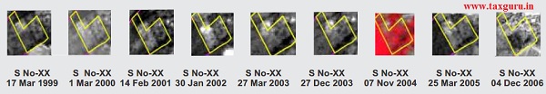
| Year | 1999 | 2000 | 2001 | 2002 | 2003 | 2004 | 2005 | 2006 |
| Vegetation | scrub | scrub | scrub | scrub | scrub | scrub | scrub | scrub |
| Trees | many | many | many | many | many | many | many | many |
| Construction | no | no | no | no | no | no | no | no |
Source- CBDT Taxalogue Magazine Jul – Oct 19 | Volume 1 | Issue 1